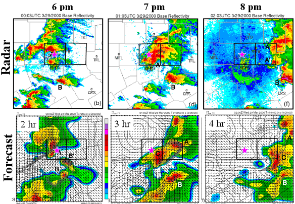
Center for Analysis and Prediction of StormsThe Center for Analysis and Prediction of Storms (CAPS) was established at the University of Oklahoma in 1989 as one of the first 11 National Science Foundation Science and Technology Centers. Its mission was, and remains, the development of techniques for the computer-based prediction of high-impact local weather, such as individual spring and winter storms, with the NEXRAD (WSR-88D) Doppler radar serving as a key data source. Along the path towards fulfilling this mission, CAPS developed the Advanced Regional Prediction System (ARPS; http://caps.ou.edu/ARPS). The ARPS is a fully automated numerical prediction system designed for both research and operational application at scales ranging from continents down to cities. It includes a data ingest, quality control, and objective analysis package known as the ARPS Data Analysis System (ADAS; http://caps.ou.edu/ADAS.html); a single-Doppler radar parameter retrieval and 3DVAR/4DVAR data assimilation system; the prediction model itself; and a web-based data display and decision support system. The value of the ARPS was recognized in 1997, when CAPS received both the Discover Magazine Award for Technology Innovation as well as the Computerworld-Smithsonian Award. When CAPS was established now well over 20 years ago, few in the scientific community believed that storm-scale weather, especially thunderstorms, possessed any reasonable degree of predictability. By 1996, CAPS had conclusively demonstrated that prediction on this scale indeed was possible, and had done so through a mix of case studies as well as real-time operational tests in close collaboration with the Norman, Oklahoma National Weather Service Forecast Office, NCEP Storm Prediction Center, US Air Force, FAA, National Center for Atmospheric Research, Pittsburgh Supercomputing Center, and the National Center for Supercomputing Applications. A key contribution of CAPS' research can best be illustrated through an example. Shown below is a sequence of hourly radar images (top panels) from the Fort Worth, Texas tornadic storms of 29 March 2000. Colors indicate precipitation intensity, with higher rates indicated by the warmer colors. The city of Fort Worth is shown by the magenta dot. Shown in the lower three panels is the equivalent radar reflectivity from a 3 kilometer-grid spacing ARPS forecast, initialized at 2300 UTC with WSR-88D (NEXRAD) radar and other data. The degree of agreement between observations and forecast, even out to 4 hours, is exceptionally good, and further improvements are anticipated with more sophisticated data assimilation techniques and forecast cycling. Of course, not all forecasts exhibit this degree of quality, and thus CAPS continues to explore fundamental issues in the predictability of small-scale atmospheric motion, including the use of ensembles as a means for dealing with uncertainty.
The opportunity to further make available the benefits of its technology led CAPS in 1999 to spearhead the creation of a private company, Weather Decision Technologies, Inc (http://wdtinc.com). The transition of CAPS' basic research concepts to operational utilization took less than a decade, a remarkable achievement and a testimonial to the impact of the STC Program. Today CAPS continues cutting-edge research in storm-scale NWP, data assimilation, ensemble forecasting and post-processing, and several other projects. For more information about current research and other activities at CAPS, visit the home page at http://caps.ou.edu/.
|